Chennai, and several adjoining districts are likely to experience heavy to very heavy rain until Tuesday morning. The downpour is connected with a deep depression, now lying over the southwest Bay of Bengal, near north Tamil Nadu and Puducherry coasts.
Since Monday late morning, most areas in Chennai have been receiving heavy spells of rain with roads getting flooded and traffic moving at a snail’s pace. Many schools declared early dismissal as showers did not cease without any break. The RMC said the system is most likely to bring more rain over Tiruvallur and Chennai districts, while scattered heavy rainfall is likely over Ranipet, Kancheepuram and Chengalpattu
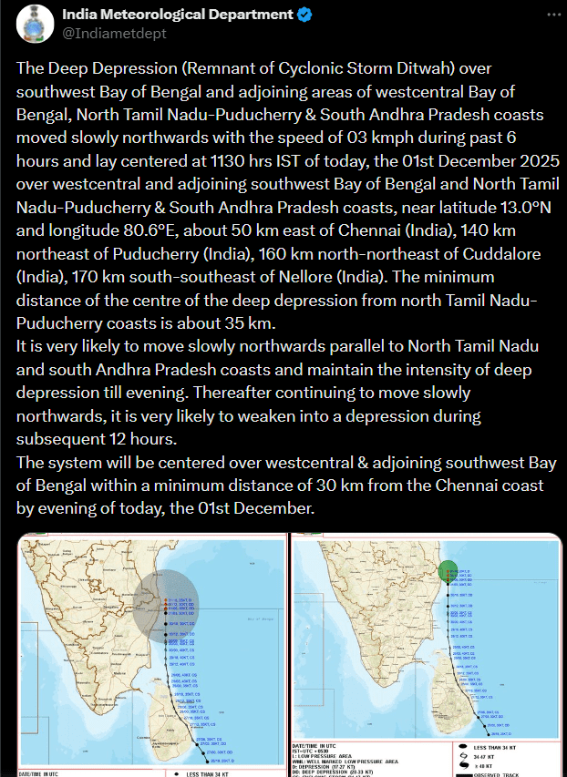
The deep depression, the remnants of Cyclone Ditwah, had moved slowly northwards at about 3 kmph as of 11.30 AM on Monday. According to the weather office, it lay about 50 km east of Chennai, 140 km northeast of Puducherry, 160 km north-northeast of Cuddalore and 170 km south-southeast of Nellore.
Chennai Weather
Waterlogging was witnessed across low-lying neighbourhoods and major roads as the rain intensified over Chennai. Railway staff were also seen pumping water out of the tracks at Egmore station to prevent service disruptions.
Three people have died in Tamil Nadu as Cyclone Ditwah impacts Tamil Nadu–Puducherry coast, unleashing heavy rain and strong winds across the region. Two fatalities were reported in wall collapse incidents in Thoothukudi and Thanjavur, while another person died of electrocution in Mayiladuthurai. Authorities also confirmed the loss of 149 cattle and damage to 234 huts across affected districts.
But, according to the IMD, the Cyclone Ditwah has weakened into a deep depression and is likely to lose further strength by tomorrow.
Meanwhile, over 400 Indian nationals, stranded at Colombo airport due to extreme weather in Sri Lanka, where the cyclone caused widespread devastation and killed more than 200 people, were flown back to India on Sunday.
Under its influence, sea conditions along the coast became turbulent. Choppy waves damaged some mechanised fishing boats anchored near Mandapam and parts of roads nearby have been breached due to severe sea erosion. Vedaranyam has been getting incessant heavy rainfall flooding several places and paralysing salt production with almost 9,000 acres of salt pans affected.

CYCLONE PREPAREDNESS ON A WAR FOOTING
puducherry hoisted the storm warning flag, number five, at its port as Cyclone Ditwah approached close to the coast and has reported moderate rain in the region as the cyclone’s eye moved closer to it. An official said 14 NDRF teams have already been deployed in vulnerable districts, including Villuppuram, Chengalpattu, Tiruvallur, Nagapattinam, Tiruvarur, Thanjavur, Pudukkottai, and Mayiladuthurai. Additional teams have also been allocated for Puducherry and Chennai. For the second consecutive day, fishermen have stayed away from the sea due to rough conditions.
Crop inundation
According to agriculture department officials 22,573 hectares of samba and thaladi crop (55,789 acres) were inundated in Mayiladuthurai, 33,043 hectares (81,653 acres) in Nagapattinam, 20,030 hectares (49,494 acres) in Tiruvarur and 5,250 hectares (12,977 acres) in Thanjavur.
Schools, colleges to remain closed on Tuesday
With Monday receiving more rainfall than earlier anticipated from the remnant of Cyclonic Storm Ditwah, causing inconvenience to school-going children, the government announced a holiday on Tuesday for schools and colleges in Chennai, Kancheepuram, Chengalpattu and Tiruvallur districts as a precautionary measure.
Following separate announcements regarding the holiday by the Collectors of these districts, Anna University said it was cancelling the university examinations scheduled for Tuesday in these districts alone.
Where is cyclone Ditwah?
“The Deep Depression (Remnant of Cyclonic Storm Ditwah) over southwest Bay of Bengal and adjoining north Tamil Nadu-Puducherry coasts moved northwards with the speed of 10 kmph during past 6 hours and lay centered at 2330 hrs IST of yesterday, the 30th November 2025 over the same region, near latitude 12.3°N and longitude 80.6°E, about 90 km south-southeast of Chennai (India), 90 km east-southeast of Puducherry (India), 110 km east-northeast of Cuddalore (India), 180 km north-northeast of Karaikal (India),” the IMD said in its latest weather bulletin on December 1.
Cyclone Ditwah brings heavy rain in Andhra
Moderate to heavy rains and strong winds were witnessed in parts of Nellore and Tirupati districts on Sunday as the cyclone Ditwah over the Bay of Bengal inched closer towards the eastern coastal regions of India. The AP govt has set up control rooms in the vulnerable districts to monitor and manage the situation arising from the cyclone, which may trigger heavy rainfall on Monday. Normal life was hit on Sunday as heavy rains lashed parts of the state, particularly Tirupati and Nellore districts.
Meanwhile, the IMD has warned that rainfall is likely to increase in some parts of Rayalaseema region and Prakasam and Nellore districts in south coastal Andhra, reports TOI. According to IMD, Tirupati, Kadapa and Annamayya districts in Rayalaseema, and Bapatla district in south coastal Andhra may receive heavy to very heavy rainfall, while districts like Chittoor, Sri Sathya Sai, Anantapur and Nandyal in Rayalaseema, and Palnadu, Guntur, Krishna, West Godavari and Konaseema in coastal Andhra are likely to get isolated heavy rainfall.
Authorities have urged the public to remain indoors, avoid unnecessary travel, and adhere to official advisories. Disaster response teams have been placed on standby as the city continues to battle intense showers, flooding in low-lying areas, and traffic disruptions caused by the persistent downpour.
ChennaiCyclone Ditwah: Latest updates
1. The cyclonic storm over the southwest Bay of Bengal has weakened into a deep depression. As per the IMD’s latest update, it moved northwards at 10 kmph in the past 6 hours and was centred at 11:30 pm on Sunday over the same area.
2. The IMD said it was about 90 km south-southeast of Chennai (India), 90 km east-southeast of Puducherry (India), 110 km east-northeast of Cuddalore (India) and 180 km north-northeast of Karaikal (India).
3. The deep depression is expected to move nearly northwards along the north Tamil Nadu-Puducherry coasts and weaken further into a depression by Monday noon. The IMD added that the system will be positioned over the southwest Bay of Bengal at a minimum distance of about 30 km by Monday morning.